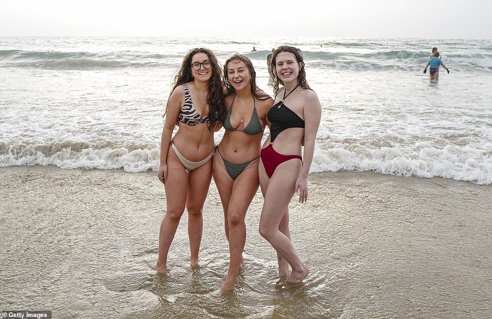
Britons flocked to beaches this afternoon to enjoy the warmest New Year's Eve on record with temperatures set to soar as high as 17C (63F) as ice rinks melted and millions across the country prepared to bid farewell to 2021.
Conditions were so warm in London that the popular Hampton Court Palace rink had to close when the surface began to melt, exactly 59 years after the nearby stretch of the River Thames froze over during the 1962 Big Freeze.
Other ice rinks elsewhere also closed due to the warm weather, including those at Somerset House in Central London, Queen's House in Greenwich and Coventry Cathedral. Leicester's Jubilee Square rink shut due to a unspecified 'technical problem', although the famous Natural History Museum rink in London stayed open.
Britons took to Twitter as they shared their amazement at the warm conditions - with one saying they 'didn't need a coat when I went out', another pointing out it was 'warm enough to walk around in just a T-shirt' and a third saying they 'don't even have my heating on'. A fourth added: 'I've got washing on the line and my back door wide open.'
But dozens of parts of the UK were on flood watch this afternoon following days of heavy rain - and the warmth comes after one of the dullest Decembers ever with less than 27 hours of sunshine across the whole month.
A new UK temperature record for December 31 was set this afternoon at Merryfield in Somerset, which reached 15.8C (60.4F) - beating the previous New Year's Eve high of 14.8C (58.6F) set in 2011 at Colwyn Bay in North Wales.
It was the fourth time today the record was broken - after 15.4C (59.7F) at Sutton Bonnington in Nottinghamshire at 1pm, 15.3C (59.5F) at Coningsby in Lincolnshire at 12pm and 14.9C (58.8F) at Ryehill in East Yorkshire at 11am.
And temperatures will stay high this evening - with the mercury set to be at 14C (57F) at midnight tonight. The last time it was warmer than 16C (61F) in the UK was November 19 when Dyce in Aberdeenshire hit 16.8C (62.2F).
The Met Office said the conditions were 'ridiculously warm' for the time of year and more akin to temperatures seen in early April - with the average daytime high for December being just 7.6C (45.7F) in England and Wales.
Today's temperatures are also expected to make parts of Britain warmer than European holiday destinations including Nice and Rome (both 16C/61F), Cyprus (Nicosia - 15C/59F), Madrid (14C/59F) and Athens (14C/57F).
It comes as revellers prepared to head out for New Year's Eve amid the backdrop of concerns over incoming restrictions with Boris Johnson set to decide next week whether to impose new rules to limit indoor socialising.
Nightclubs in England, which are still allowed to open unlike neighbouring Scotland and Wales, have been offering half-price deals in a bid to encourage revellers to ring in 2022 with them. And many Britons took to Twitter to declare they are #notgoingout on New Year's Eve tonight as the country remains gripped by the Omicron crisis.
Tomorrow could also be around the New Year's Day record of 15.6C (60F), set in 1916 in Cornwall. The December record for England is 17.7C (63.9F) in 1985, while for the UK as a whole it was 18.7C (65.7F) in 2019 in Scotland.
The Met Office said two new all-time highs for New Year's Eve and New Year's Day would create the 'unusual situation of one weather system perhaps breaking weather records for two days in separate calendar years'.
An area of low pressure over Ireland is dragging warm air up from the coast of Africa, before temperatures in the daytime take a dramatic plunge from Tuesday, falling to highs of 8C (46F) in the South and 5C (41F) in the North.
But despite the warmth in recent days, which has seen the UK hit 60.3F (15.7C) both yesterday and on Wednesday, much of the UK has experienced grey skies and heavy rain which have caused some rivers to burst their banks.
And many areas were on flood watch today - with a total of 70 flood alerts across the UK including 51 in England, 17 in Wales and two in Scotland, as well as one flood warning threatening the West Yorkshire village of Walsden.
Britain's dullest ever December was 65 years ago, when 19.5 hours of sunlight was the national average, while the sunniest was in 2001, with 64 hours recorded on average across the UK. This month has seen a total of just 27 hours so far, which is 38 per cent less sunlight than the December average and the lowest total since 1956.
Confirming the New Year's Eve temperature record had been broken at 11am this morning, Met Office spokesman Stephen Dixon said: 'Our station at Ryehill, a small village in East Yorkshire, has recorded 14.9C (58.8F) today.
'(This) tops the previous record of 14.8C (58.6F). It has provisionally broken the New Year's Eve record. We would expect that to climb further and reach temperatures we saw yesterday of around 15.5C (59.9F).'
The Met Office then tweeted shortly after noon: 'Provisionally, Coningsby in Lincolnshire has recorded 15.3C (59.5F) so far today, meaning today is the warmest New Year's Eve on record for the UK.'
An update in a Met Office press release issued at about 1.30pm then reported the new high of 15.4C (59.7F) at Sutton Bonnington in Nottinghamshire.
This was then updated again shortly before 2pm with a tweet for the forecast agency saying: 'Temperatures have continued to climb this afternoon with Merryfield in Somerset recording 15.8C (60.4F) so far.'
Earlier, Met Office meteorologist Rachel Ayers said: 'In the south of the UK the weather should be dry for tomorrow so people should be able to enjoy dry weather with some bright spells around.
'For New Year's Day, another band of rain is pushing in from the west so the further east you are the drier your day will be with some bright spells.'
On New Year's Eve, the UK can expect to see early rain across central, eastern and southern England which will clear eastwards to leave a brighter and drier day.
It is expected to be 'exceptionally mild' with temperatures up to 14-15C (57-59F), and a possible high of 16C (61F), Ms Ayers said.
Across Northern Ireland, Scotland and northern England, cloud and outbreaks of rain will linger for much if not all of the day, though it will become patchier.
It will be a windy day for many, particularly across north Wales and northern England.
Recent very mild temperatures on New Year's Eve include in 2018 when Dunrobin Castle Gardens, Sutherland, reached 14.5C (51F) and 2011 when Colwyn Bay reached 14.8C (51.28F).
The Colwyn Bay maximum is the highest in the Met Office's digitised database which contains data going back to the 1850s.
Met Office senior operational meteorologist Marco Petagna tweeted today: 'As we enter the final day of 2021 it's set to be a record breaker.
'The New Year's Eve high temperature record for the UK is 14.8C Colwyn Bay 2011. We're set to smash that today, with highs of 16, possibly at a push 17C!'
For New Year's Eve night, bands of rain will continue to spread north-eastwards, mainly affecting Northern Ireland, Scotland and northern England.
Yesterday's unseasonably toasty weather was enough to tempt out day trippers as far afield as Tynemouth, where children built sandcastles on the beach, to Cambridge, where families enjoyed the traditional summer pastime of punting on the Cam.
In Bournemouth surfers made the most of the waves, while in London jugglers in their shirtsleeves performed on unicycles in Covent Garden. Temperatures in both places were 14C (57F).
The capital could also be the setting for today's expected record temperature, thanks to less breeze than in previous days.
Met Office meteorologist Greg Dewhurst said: 'We're going to see across the whole of the country temperatures that are above average for this time of year.
'We're looking at highs of around 12-14C (53-57F), possibly locally 15C in one or two spots, so it's going to be well above average.'
The mild temperatures have also contributed to the persistent dull weather, however. Only three Decembers in 100 years have had less sunshine than this month.
Forecaster Craig Snell of the Met Office said: 'One of the reasons we're getting the dull weather is the fact that it's been so mild. We're drawing in south-westerly wind from the Atlantic and it's also drawing in a lot of moisture.'
'It keeps us warm but also produces a lot of cloud. The globe is warming up so expect our winters to get milder.
'We always have milder spells throughout the year, so we can't link every mild spell to climate change, but we can say that extremes in our weather will become more common as we continue through this century.'
Speaking about Scotland's forecast for tonight, Mr Snell added: 'It will be ridiculously warm for the time of year.
'I know there are restrictions on social gatherings in Scotland but anyone who does leave the house after midnight will encounter temperatures more akin to springtime – and during the day at that.'
In Scotland, places such as Glasgow, Inverness and Aberdeen could see a bit of rain as the country approaches 2022, with the South-East of the country remaining dry.
New Year's Day will see some improvement, with most people seeing some brightness at some point in the day.
Temperatures will start to slip away on Sunday, when 10C (50F) is still possible, but by Monday the mercury will be down to single figures.
Bob Ward, policy director at the Grantham Research Institute on Climate Change, part of the London School of Economics, said: 'Winters have been getting warmer and wetter for some time now.
'The bitterly cold days we used to experience in December will become less frequent, all down to climate change. It is going to play havoc with plants and animals.
'It is becoming so warm, some species simply won't disappear in winter. Animals which traditionally hibernate in winter will be confused by the higher temperatures.'


Comments
Leave a Comment