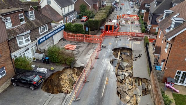
Sinkholes opened up in the middle of a Surrey village forcing the high street to be closed and a local residents to be evacuated during the week.
After the 65ft long and 20ft wide sinkhole appeared on Monday night in the village of Godstone, forcing Surrey County Council to declare a major incident.
On Wednesday a smaller second sinkhole appeared near the first one with pictures showing a car which is on the brink of plunging into it.
Homes and businesses in the area have been evacuated over fears of an explosion caused by cables left exposed by the collapsed road.
Residents evacuated from 30 properties have said they do not know when they will be able to return to their homes while some properties have been left with out water due to a burst water main within the sinkhole.
But what is a sinkhole and why did the one in Godstone appear?
Sinkholes are large pits that appear in the ground when underlying rock collapses or is washed away, dissolved in water or degraded for other reasons.
They are typically 5 to 10 metres deep but can have a depth of more than 50 metres.
Sinkholes form as a result of soluble rock being dissolved by acidic rainfall or groundwater, causing the overlying ground to collapse.
Sinkholes can be triggered by heavy rain, surface flooding and drought because they can destabilize underground cavities.Another factor can be mining, burst water mains and construction work because they affect surface drainage and loads that ground has to bear.
Areas that are more likely to be hit by sinkholes are The Mendips, parts of Wales, the Peak District and the northern Pennines because they sit on carboniferous limestone, a hard sedimentary rock made of calcium carbonate.
Other vulnerable parts of the country are areas of Dorset, Hampshire and the Chilterns, where clay and sand sit on chalk.
The biggest sinkhole hotspot in Britain is around Ripon in North Yorkshire, because its sits on gypsum, a soft mineral that dissolves significantly more than limestone.
Beneath Godstone are a network of tunnels and derelict sand mines that date back to the 17th century.
Locals have told The i Paper they believe the sinkhole opening up was caused by a sand mine under the high street which they believe collapsed – but there are no records of any being located beneath it.
Godstone is in an area which is very susceptible to landslips and geologists believe the most likely cause for the sinkhole is movements of rock underground.
The whole area is made up of a landslip formation called Lower Green Sand -which includes coarse-grained sands and weakly cemented sandstones.
Geologist, Dr Andrew Farrant, regional geologist of the Southeast England British Geological Society told The i Paper: “It is probable that a burst water main has flushed out weak sandstone bedrock, creating a void which has then collapsed.
“We cannot definitely say what caused this event without further information.
“It is probable that the sinkhole is due to a burst water main flushing out weak unconsolidated sands from beneath the road over a period of time, creating a cavity which then collapsed when it got big enough, but it could also be linked to the collapse of an old unrecorded sand mine.”
“Historical maps show there was a sand quarry near the site of the sinkhole but this has been built on and filled in,” Dr Farrant added.
He also explained two other old mines have entrances south of the sinkhole, on the east side of the road.
Dr Farrant did not rule out a cave collapse being the cause of the sinkhole as he believes there could be further sand mines in the area that are not recorded on maps.
Geologist Dougal Jerram believes the area’s geographical make up is the cause for the sinkholes appearing.
He told GB News: “Unfortunately the geology around the whole area is made up of a formation called the Lower Green Sand.
“This is one of the most landslip susceptible formations in the UK. Normally if the rocks are contained that’s fine. But it obviously in this case something has caused some of the more unconsolidated material to be removed.”
Dr Phil Collins, deputy dean in the College of Engineering, Design & Physical Sciences at Brunel University of London, also agreed and said a contributing factor was soil moving due to the burst water pipe.
He said: “One of the contributing factors is the local geology, which is sand, and the former land use which is a sand quarry that was located immediately to the west of the sinkhole.
“Sand can be strong when compacted as the particles are packed together, but weak when it becomes wet, and particularly if there is a lot of water under pressure.
“This burst would have pumped a large volume of water into the soil in a short period of time, overcoming its strength and turning it to a slurry which was then washed away.”
He said it is “unclear is why the mains pipe ruptured” – but one possibility is “soil movement” caused the pipe to “deform” or “a structural failure in the pipe or a nearby sewer”.
Dr Collins added it is likely soil moves by the burst main is likely to have “gone into nearby sewers”, which may cause problems elsewhere.
Mr Jerram supported his claim, saying: “What’s probably happened is there’s been a small collapse that’s disrupted the pipe. More water has come in, and the minute you’ve got more water in, you’ve got a process by which you can remove sand more rapidly.
“I suspect that’s what’s happened in this case. It’s worrying stuff.”


Comments
Leave a Comment