These were the unexpected scenes across Britain yesterday as the country prepared to give a particularly warm welcome to 2022.
Temperatures this New Year's Eve could hit a record 15C (59F) – compared with the average of 7-8C (44-46F).
Incredibly, for many across the country, December 31 is likely to be warmer than Midsummer's Day on June 21, when temperatures struggled to reach an unseasonably chilly 57F (14C).
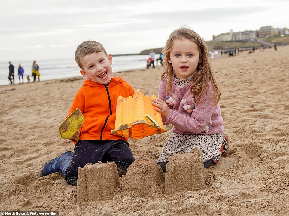
And yesterday's unseasonably toasty weather was enough to tempt out day trippers as far afield as Tynemouth, where children built sandcastles on the beach, to Cambridge, where families enjoyed the traditional summer pastime of punting on the Cam.
In Bournemouth surfers made the most of the waves, while in London jugglers in their shirtsleeves performed on unicycles in Covent Garden. Temperatures in both places were 14C (57F).
The capital could also be the setting for today's expected record temperature, thanks to sunny spells in the afternoon and less breeze than in previous days.
It's a far cry from the icy days of 1962, when London and the rest of the country experienced a Big Freeze going into 1963, with temperatures going as low as minus 20C. Pictures taken during what was the coldest winter in Britain since 1740 even showed one enterprising milkman doing his round in Earls Court on skis.
Today's expected warmer weather will follow one of the dullest months on record, which saw the UK receive less than 27 hours of sunshine – 38 per cent less than the December national average and the lowest December sunlight total since 1956.
The current temperature record for New Year's Eve was 14.8C (58.6F), which was measured in Colwyn Bay in north Wales ten years ago.
Met Office meteorologist Greg Dewhurst said: 'We're going to see across the whole of the country temperatures that are above average for this time of year.
'We're looking at highs of around 12-14C (53-57F), possibly locally 15C in one or two spots, so it's going to be well above average.'
The mild temperatures have also contributed to the persistent dull weather, however.
Forecaster Craig Snell of the Met Office said: 'One of the reasons we're getting the dull weather is the fact that it's been so mild. We're drawing in south-westerly wind from the Atlantic and it's also drawing in a lot of moisture.'
During the Big Freeze, a blizzard on December 29 and 30 across Wales and south-west England caused snowdrifts nearly 20ft deep, following a white Christmas where nearly a foot of snow fell across southern England.
Despite the warmth, the north of England is facing flood chaos due to heavy rains.
One flood warning in Lostock, Greater Manchester, and 43 flood alerts have been issued across the country today, with the Met Office predicting showers in 'many areas' tonight and 'very mild' conditions.
In its flood forecast for the next five days, the weather service says: 'Local flooding from rivers and surface water is possible in parts of Wales and the north of England today (Thursday) and tomorrow (Friday) due to heavy rain.'
The December record for England is 17.7C (63.9F) in 1985, while for the UK as a whole it was 18.7C (65.7F) in 2019 in Scotland.
By Monday and Tuesday, however, there could be 'some wintry showers on high ground' such as the North Pennines and rain elsewhere, Mr Miles said.
But the change is also predicted to finally clear some of the cloud, bringing a chance of sunshine – which has been in short supply.
Daytime temperatures will likely take a dramatic plunge – falling to single figures by Tuesday, with highs of 8C (46F) in southern England and just 5C (41F) in the North East.


Comments
Leave a Comment